Everest Base Camp Trek
Trekking to Everest Base Camp is the most popular route not only in Nepal, but in the Himalayas in general. The presence of many shelters, Sherpa porters and equipped trails allows you to travel very comfortably at altitudes of about 5000 meters. To do this, you don’t need to be a mountaineer - ordinary (hiking) hiking experience is enough. You can see Everest with your own eyes - make up your mind!
Trekking to Everest Base Camp is the most popular route not only in Nepal, but in the Himalayas in general. The presence of many shelters, Sherpa porters and equipped trails allows you to travel very comfortably at altitudes of about 5000 meters. To do this, you don’t need to be a mountaineer - ordinary (hiking) hiking experience is enough. You can see Everest with your own eyes - make up your mind!
Why should you come with us?
- You will be led to Everest by the most experienced instructor of the tourist club - its leader (in Nepal since 2009).
- Our acclimatization schedule is 1-2 days longer (i.e. 20% safer) than most of our fellow competitors. And the price is the same.
- 10% discount if there are three or more of you
- We enter Amadablam base camp
- The instructor makes a cool video and takes good photos (see below). He'll take pictures of you too :)
Trek plan:
80% of the trek to Everest Base Camp takes place in the high altitude zone, where there is much less oxygen than our lungs would like. To cope with this route, you must, firstly, actively prepare at home (run a lot), and secondly, follow an acclimatization schedule. From Lukla to Everest there are only 50 kilometers horizontally, but for the sake of acclimatization we will stretch their passage over 9 days (we will go back down in 3 days).
RouteRoute map
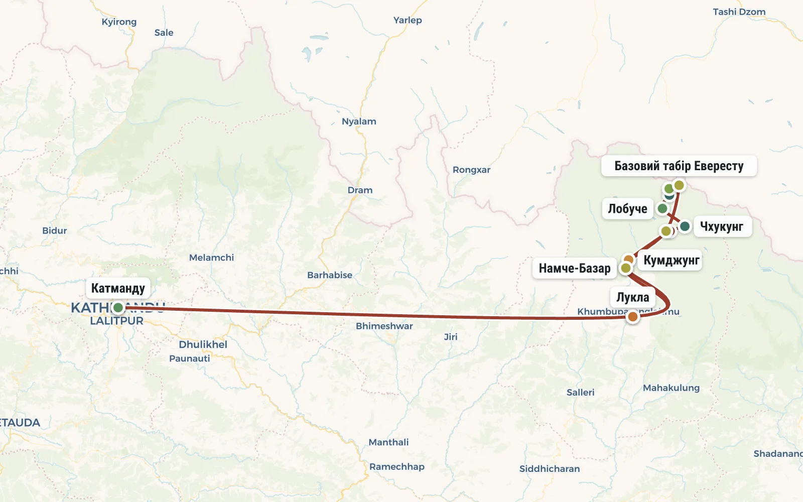 Open the map →
GPS-трек для маршруту ще не оцифровано — лінія орієнтовна (по ключових точках).
Day by dayItinerary
1 Day 1. Flight to Nepal, connection in the UAE.
In most cases, the cheapest way to get to Nepal is to fly with AirArabia or FlyDubai with a connection in the UAE. The price is about 650 dollars (round trip). The only drawback is the long connection. Usually you have to wait at the airport in Dubai or Sharjah all night. To rest comfortably in the waiting room, you can take a sleeping bag with you. Sometimes there are attractive prices for tickets from Turkish Airlines, which are generally more comfortable than Arab low-cost airlines.
2 Day 2. Arrival in Kathmandu
Another 5 hours of flight and you are in Kathmandu. Right at the airport, fill out a visa application and buy a visa for 2 weeks ($25 + 1 photo). It makes sense to buy a Nepalese SIM card right there at the airport (about $10). There is quite decent coverage on the trek to Everest Base Camp, and even mobile Internet works. After finishing all your business at the airport, take a taxi to the hotel - we will book it in advance and send you detailed instructions for getting there.
We will book a hotel in Kathmandu in advance and send you detailed instructions on how to get there (by taxi). An instructor will be waiting for you at the hotel, who will check the availability of the necessary equipment and, if possible, help you purchase what is missing (there is a lot of interesting equipment in Kathmandu).
In the evening, the group gathers together in a restaurant to discuss plans for tomorrow. Early lights out.
3 Day 3. Flight to Lukla, Phakding (2652 m).
Immediately after breakfast we leave for the airport. By the way, excess things can be left for storage at the hotel. At the airport, the most important process awaits us - weighing our luggage. Since very tiny planes fly to Lukla, the baggage allowance is very strict - 10 kg (main) + 5 kg (hand luggage).
After registering, we go to the waiting room to pray to the gods of luck. Tickets to Lukla will be booked almost a month before the trip. But that doesn't mean much. In practice, everything will depend on the weather - Lukla is often covered in clouds and then flights are stopped.
It only takes half an hour to fly from Kathmandu to Lukla, but it’s even more fun to see how everything around you changes. Crowds of porters, climbers dark with a mountain tan, caravans of yaks and, of course, that same terrible landing strip with its ends resting on a rock and an abyss.
In Lukla (altitude 2800 m) we will be met by our Sherpa porters (at least one per group). We will give them some of the luggage, repack the rest, have lunch and hit the road. Our destination for today is the village of Phakding (altitude 2652 m). A wide paved path leads to it, surrounded by rice terraces and colorful Nepalese shacks.
Travel time - 4 hours, descent - 200 m.
4 Day 4. Namche Bazaar (3440 m)
We go upstream of the Dudh Kola River, crossing from bank to bank several times along suspension bridges. A couple of hours after the start, in the village of Monjo, we pass the main gate of the Sagarmatha National Park (Nepalese name for Everest). The instructor issues passes for all group members. Dinner.
The main adventure of today is the long climb before Namche Bazaar. It will be a little difficult if you're not used to it, but you can handle it. We walk through a coniferous forest, where you can often see Nepalese pheasants. At the end of the climb there is another checkpoint.
Finally we arrive at Namche Bazaar (altitude 3440 m). This is a huge village with many hotels, shops and restaurants. This is your last chance to realize that you don’t have enough warm clothes (it’s already noticeably cold here in the evenings) and buy the missing equipment.
Travel time - 6 hours, elevation gain - 1000 m, descent - 100 m.
5 Day 5. Acclimatization hike to Kumjung (3780 m), Yeti scalp.
Our things remain in Namche Bazaar, and we go to the radial for the whole day. Our task is to adapt to the altitude. And for this you need to move.
To get out of Namche, located in a huge “circus”, to the plateau we need, we need to overcome a climb of several hundred meters. And here many of you will feel for the first time that there is no longer enough oxygen - weakness in the legs and noise in the head become noticeable as soon as you try to go up. We walk deliberately slowly, breathe a lot and take photographs. We make a stop at the helipad of an expensive “Japanese” hotel.
We cross a ridge of picturesque hills overlooking Ama Dablam and arrive at the quiet village of Kumjung (3780 m). We see the longest prayer wall in Nepal, "mani", have lunch in one of the shelters, and slowly make our way through the stone labyrinth to the Buddhist gompa. In this small monastery, in a funny iron box, the scalp of a Bigfoot is kept.
If the weather permits, then after the monastery we climb onto the neighboring slope to gain another 200 meters in height. Acclimatization requires patience and persistence.
On the way back to Namche we pass a farm where yaks are bred. Funny furry calves perfectly complement the idyllic rural pastoral. The descent is quite easy... We pass the Syangboche airstrip, which, unlike Lukla, is intended exclusively for cargo delivery. It is from here that yak caravans loaded with oxygen cylinders, food, fuel and other expedition belongings start for the Everest base camp. We return to Namche Bazaar.
Travel time - 8 hours, elevation gain - 600 m, descent - 600 m.
6 Day 6. Tengboche (3860 m), Deboche (3710 m)
Just beyond Namche Bazaar, a path of incredible beauty begins. This is a traverse with minor elevation changes and gorgeous views. To our right, the six-thousand-meter peaks Tamserku and Ama Dablam shine with snow. And in good weather, far ahead, you can see the top of Everest (a very small piece).
We have lunch in the village of Phunki Tenga, cross another suspension bridge and after the army checkpoint we begin a grandiose 600-meter climb to the village of Tengboche. It will be hot and fun (don't overeat at lunch).
The survivors after a tiring climb gather in Tengboche, in a restaurant at the gates of the famous Buddhist monastery - the largest in the region. When we cool down (freeze, get dressed, drink tea and finally wait for those who are lagging behind), we will go inside the main temple for an excursion. If we're lucky, we'll be able to watch a service take place here or a sand mandala being drawn.
From the monastery to our overnight stay it is only 30 minutes of gentle descent. We stop in the village of Deboche (3710 m).
Travel time - 6 hours, elevation gain - 800 m, descent - 400 m.
7 Day 7. Pangboche (3930 m), radial to Amadablam base camp (4500 m).
In the morning we pass the remains of the destroyed bridge and cross the river again. Here she already has a different name - Imja Khola (and our Dudh Kosi turned towards the lakes of Gokyo). But this does not change the essence - we are going upstream, to the grandiose Khumbu glacier (there are still 2 days to go). Immediately after the bridge the ascent begins, and immediately beyond the ascent is the village of Pangboche, where we are spending the night today. Yes, we will arrive at our overnight stay very early, but it’s still too early to relax - there’s a long acclimatization radial ahead to the Amadablam base camp (4500 m).
We quickly have lunch (although it’s more like a second breakfast), load up the thermos and head out into the radial cell. To do this, we cross the river again just above Pangboche and begin a long climb to the shepherd camps of Rala Kharka and Lhabarma (approximately 4200 m). If time and well-being permit, we gain another 300 meters of altitude and arrive at the Amadablam base camp (4500 m). In the evening we return to Pangboche. Be sure to take flashlights and warm clothes with you. The entire radial will take from 4 to 7 hours.
Travel time: 5-8 hours, elevation gain - 800 m, descent - 100 m.
8 Day 8. Dingboche (4360 m), radial at 5000.
Near the confluence of the Imja Khola and Khumbu Khola rivers, we cross a bridge and begin the ascent to today’s overnight stay - the village of Dingboche (4360 m). We check into the lodge, have lunch, leave a reservation for dinner and head out into the evening radial along the spur of the neighboring Nagartsang mountain (5551 m). It would be nice to crawl to the intermediate peak at around 5000 m, but this is not so important.
Travel time - 5 hours, elevation gain - 600 m, descent - 100 m.
9 Day 9. Radial to Chukung (4750 m), ascent to Chukung Ri or Island Peak base camp.
We have reached a very important height and before we continue to increase it, we must give the body time to adapt. Therefore, today we will remain at the already “conquered” height and will again spend the night in Dingboche (4360 m). And to occupy the day with something, we’ll go on a radial hike to the village of Chukung (4750 m), perched at the foot of the Lhotse glacier (this is halfway to Island Peak). If this doesn’t seem enough, then after lunch you can climb slightly along the path leading to the peak of Chukung Ri (5559 m) or walk a little more along the valley towards the Island Peak base camp.
Travel time - 9 hours, elevation gain - 600 m, descent - 600 m.
10 Day 10. Dugla (4600 m), Lobuche (4940 m)
Beyond Dingboche we climb onto a small plateau and traverse for a couple of hours along an easy trail with panoramic views. Near the village of Dugla (it consists of three houses) we have a light snack and prepare for the climb. We have to climb 300 meters (imagine this scale) to climb the leading edge of the moraine ridge of the Khumbu glacier.
At Thokla Pass there is a memorial to the fallen climbers - numerous stone tours, lungta prayer flags and memorial plaques. Usually on the other side of the pass the ground is already covered with snow, so here we will stop to change our boots. After all, before this we walked mainly along dry dirt paths, where we could easily walk in sneakers.
About another hour of walking and we are in the village of Lobuche (4940 m). We check into the lodge, replenish our supplies of tea in thermoses and go to the evening radial. As always, in order to sleep well at night you need not to be lazy, but to gain 200-300 meters. Usually we go to the spurs of Mount Lobuche East (6119 m), but in case of bad weather we can choose a shorter route and go to the moraine ridge.
We have already reached the point where almost everyone is guaranteed to feel the effects of a lack of oxygen. The appetite disappears, the head hurts, the legs don’t obey, the heart jumps out of the chest. The body is extremely vulnerable and easily “catches” any sores. For the next 2 days (and 2 nights) you need to be very attentive to your well-being and tell the instructor about everything.
Travel time - 5 hours, elevation gain - 800 m, descent - 200 m.
11 Day 11. Gorakshep (5170 m), Kala Patthar (5550 m)
One of the hardest days of the journey begins. The path to Everest Base Camp is still wide and gentle, but my weak legs can barely crawl. I want to sit on a warm stone and not move... We continue to crawl through the stone chaos along the Khumbu glacier.
Even before noon we arrive at Gorak Shep (5170 m), check into a shelter and have lunch. If the sky is clear, then we immediately pack our backpacks for the climax radial. It will be very cold and windy at the top - to sit calmly at the top you will need all the warm clothes (mittens!).
We are going to Mount Kala Patthar (5550 m). From here it looks completely undignified - a kind of black mound against the backdrop of the majestic seven-thousander Pumori. But don’t expect an easy victory - the road to the top will take several hours of endless struggle with your weakness.
Do you know why we came here? Kala Patthar is an observation deck - from here you can clearly see Everest (finally!) and the endless expanses of the glacier with barely noticeable tents of the base camp. We sit, drink tea and think about the meaning of life.
Having used up the body's heat reserves, we begin our descent to Gorak Shep. Tomorrow we have an early rise and a very long day - we need to try to sleep (not everyone will be able to do this).
Travel time - 3 hours, altitude gain - 300 m.
12 Day 12. Everest Base Camp (5316 m), Pheriche (4270 m)
We go to the radial to Base Camp. We start very early, with the first rays of the sun. Before we leave, we pack our backpacks and vacate the rooms - by noon a new wave of people who want to see Everest will come here, and we may not have time to return to this point.
Although the elevation gain here is much less than in the foray to Kala Patthar, it is still very difficult to walk. The cold morning air burns your lungs - it is better to breathe through a scarf, buff or neoprene mask. First we ride along the moraine for a couple of hours, and then we completely descend onto the glacier.
Base camp is a very vague concept. There are not always crowds of climbers and hundreds of tents here. But regardless of their presence, there is something to do and see (I mean the gorgeous glacier). After walking around, we go back to Gorak Shep, have breakfast and get ready for the start.
Our task is to reduce the altitude as much as possible and reach Pheriche today (this is next to the already familiar Dingboche). Surprisingly, the legs go down very quickly. We have lunch in Dugla (4620 m). The abundance of oxygen wakes up your appetite again :)
We walk along a wide valley along the Lobuche Khola River. Directly ahead is Mount Amadablam again and, frankly, in the setting rays of the sun it looks no worse than Everest. We pass pastures where funny, furry yak calves are fed. Already at dusk, quite tired, we tumble into Ferice (4270 m).
Travel time - 12 hours, elevation gain - 200 m, descent - 900 m.
13 Day 13. Descent to Namche Bazaar (3440 m)
We continue our descent. After several days of stone and ice hell, it is extremely pleasant to see trees and pale Himalayan grass. We have two options for the route - along the familiar path through Tengboche or along the new, slightly longer and more spectacular route through Phortse. And of course, both routes are not only beautiful, but also tiringly long, you won’t be able to get through :)
We are already in those areas that in the evenings are completely covered with clouds and in the second half of the day we will be sailing “on instruments”. But even when immersed in an impenetrable fog, it is useful to look around. In such weather, wild goats often graze just a step away from the path.
In Namche Bazar we begin to make inquiries about the weather in Lukla, the instructor contacts the airline and confirms the reservation.
Travel time - 9 hours, elevation gain - 300 m, descent - 1000 m.
14 Day 14. Lukla (2800 m)
We descend into the forest area. It’s unusually warm and full of oxygen here :) At the same time, due to the high pace and constant maneuvering among the yaks and weaving tourists, you feel wildly tired. We go, we go and we go again (it's time for lightweight sneakers again).
Upon arrival in Lukla, we once again confirm our return plane tickets, find out the weather report, and only after that we relax.
Travel time - 8 hours, elevation gain - 300 m, descent - 1000 m.
15 Day 15. Flight to Kathmandu.
Since the morning we have been sitting at the airport and guarding our flight. If we’re lucky with the weather, we fly to Kathmandu and within half an hour we’re drenched in sweat in an unusually hot and noisy city. If we're unlucky, we'll rebook tickets for tomorrow's flight. It's good that we have a whole day left (tomorrow).
16 Day 16. Tour of Kathmandu - Pashupatinath, Boudhanath, Swayambhunath, Royal Square.
If you concentrate (wake up early) and travel by taxi, then all the main attractions of Kathmandu can be seen in one day.
Usually the order of review is as follows: in the morning the Hindu temple complex of Pashupatinath (sadhus saints, crematorium by the river, Shiva the bull), then the huge Buddhist stupa Boudhanath, moving to the other end of the city and climbing the observation hill of Swayambhunath (Monkey Temple). Towards the end we visit the Royal Durbar Square, where the girl goddess Kumari lives.
DetailsIncluded
Not included
The tour price does not include:
Trip conditions
This is not a hike in our understanding of the word, but trekking. We do not carry tents or food in our backpacks. All overnight stays on the trek take place in tourist shelters - lodges. That's where we eat. The only equipment we take with us is sleeping bags. We usually hire several porters to transport some of the luggage. Each person gives them an average of 5 kg of cargo.
The route is subject to changes (depending on the weather and the condition of the group. Prolonged bad weather in Lukla can also significantly affect our plans. Sometimes, in order to catch the plane home, we have to call a helicopter ($500 per person).
To participate in trekking to Everest Base Camp, you must have hiking experience, experience at altitudes above 3000 m is highly desirable, and there are no medical contraindications.
Booking
Порядок оплаты: Чтобы забронировать место в группе надо внести предоплату - 50 евро. В случае отказа от участия, предоплата не возвращается, но может быть передана другому участнику или сохранена на будущее (для оплаты других туров). Остаток стоимости тура оплачивается при встрече группы в Турции. В случае преждевременного схода с маршрута, деньги не возвращаются.
ReviewsTraveller reviews
Похід у базовий табір Евересту був однією з моїх цілей які треба було виконати до 30 років. Я залишився задоволений і під враженням. І остаточно закохався у гори.
За то, что все-таки побывала в базовом хочу поблагодарить Кирилла, инструктора. Последний отрезок пути он просто очень медленно шел сзади меня. Ничего не говорил, но я просто кожей ощущала его поддержку; как будто делился своей энергией для того, чтобы смогла дойти.
Всё это добавило разнообразия и сделало путешествие еще более запоминающимся.
Зато когда на вершине вдруг подул ветер и разогнал тучи, то у народа челюсти попадали. Над Эверестом пламенел закат.
Я на этот случай помимо флисовых перчаток взял утепленные верхонки (продаются в Намче, рекомендую) и чувствовал себя превосходно.
Гори – це Подорож. Кілометри доріжок, нових, або знайомих. Але навіть ходжені вздовж і впоперек маршрути кожного разу різні. Гори – це почуття дому на іншому краю Землі. А ще це просто неймовірно, до втрати слів красиво!
Непал точно не підходить для тих, хто спішить. Замість нервово метатися туди-сюди краще присісти на сонечку, випити чаю з термоса і насолодитися весною. Ввібрати в себе все навколо, задуматися, піти вглиб себе.
Намче Базар это ворота, ведущие к Эвересту. И я здесь, я добрался! В Намче ноги сами начали нести вперед, голова вращалась на 360 градусов, а память GoPro начала очень быстро заканчиваться. Все было похоже на какой-то сон.
А команда лучше всех похвал, яркие, интересные и веселые люди, всем спасибо и надеюсь вместе еще сходим туда где еще не бывали!!! Всем, кто собирается - удачи, впереди много работы, будет нелегко, но оно того стоит.
Большая заслуга в этом и отдельное спасибо нашему руководителю, Кириллу, за очень грамотно спланированную акклиматизацию.
Идти на трек только с классным руководителем и с компанией, которая себя зарекомендовала (только OutdoorUkraine и только Кирилл).
Кирилл, большое спасибо за идеально организованный поход!
И я хочу каждому сказать - собирай рюкзак и иди! В таких местах нужно оказаться хоть однажды. Оutdoorukraine в лице Кирилла - это надежное плечо рядом на протяжении всего маршрута.