Everest base camp + Gokio
Trekking to Everest Base Camp, visiting the Gokyo Lakes and conquering the Cho La Pass is the steepest route you can think of. Unlike a short 2-week tour to Everest, this route allows you not only to see much more (for example, Everest is visible more often and better here), but also more safely, without rushing to undergo high-altitude acclimatization (the maximum altitude on the route is 5550 m). Thanks to the presence of 3 spare days, the chances of waiting out bad weather in Lukla are significantly increased. And if the program is completed ahead of schedule, we will go on a safari to the jungle of the Chitwan Nature Reserve. The only question is, are you ready for Everest?
Trekking to Everest Base Camp, visiting the Gokyo Lakes and conquering the Cho La Pass is the steepest route you can think of. Unlike a short 2-week tour to Everest, this route allows you not only to see much more (for example, Everest is visible more often and better here), but also more safely, without rushing to undergo high-altitude acclimatization (the maximum altitude on the route is 5550 m). Thanks to the presence of 3 spare days, the chances of waiting out bad weather in Lukla are significantly increased. And if the program is completed ahead of schedule, we will go on a safari to the jungle of the Chitwan Nature Reserve. The only question is, are you ready for Everest?
In most cases, the group is accompanied by two instructors. The first is “our”, Russian-speaking guide from OutdoorUkraine. He will lead the group, monitor the well-being of the participants, tell scary stories about the “black climber,” maintain contact with the “mainland” and make all the important decisions during the trek to Everest. The second instructor, a Nepalese, will be the main liaison with the local population. It is he who will “lobby” our interests at the airport (later you will understand how important this is), take good places in the lodges and control the Sherpa porters. The Nepalese guide does not speak Russian, but he speaks simple and understandable “school” English.
Travel plan:
RouteRoute map
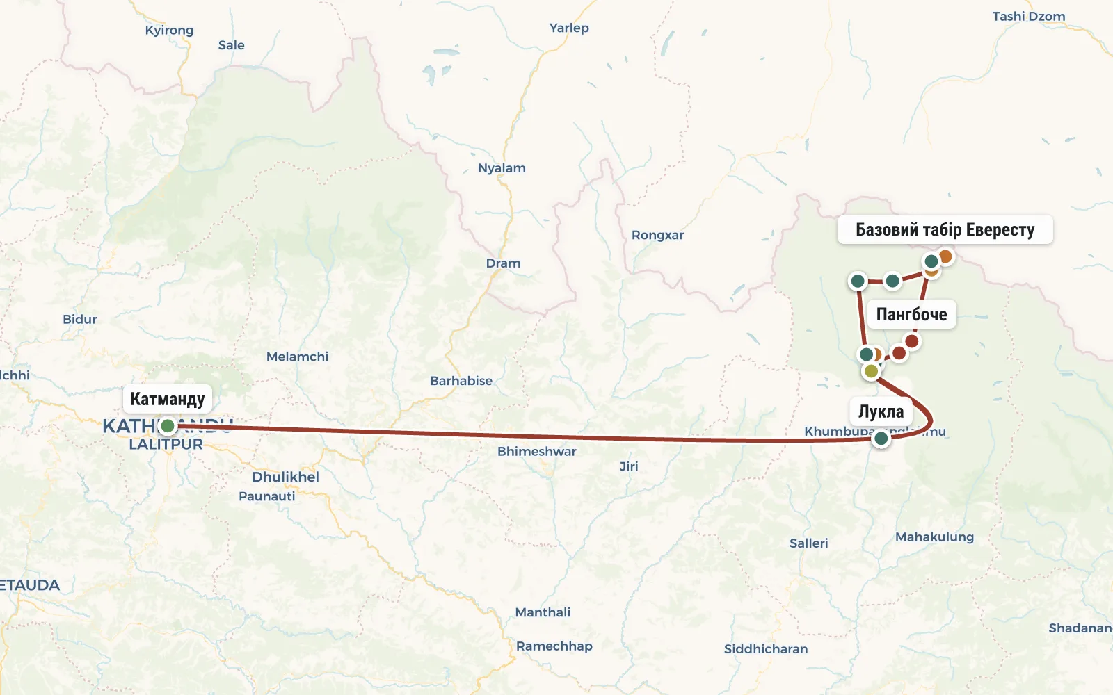 Open the map →
GPS-трек для маршруту ще не оцифровано — лінія орієнтовна (по ключових точках).
Day by dayItinerary
1 Day 1. Flight to Nepal, Sharjah or Dubai airport.
You can fly with any airline convenient for you. Usually these convenient ones turn out to be FlyDubai (with a transfer in Dubai, UAE) or AirArabia (with a transfer in Sharjah, UAE) - they regularly fly from Kyiv, Moscow, Kharkov, Kazan, Yekaterinburg and Odessa. Tickets cost $700-800. It's about a 5-hour flight to the emirates, then a long connection. Basically a whole night in the waiting room. Don't forget the maps - at least you'll have something to do. Most likely you won’t want to go out into the city - there’s a lot of hassle with getting an Arab visa (70 bucks).
2 Day 2. Kathmandu
The flight from Sharjah (Dubai) to Kathmandu will take about 5 hours. At the airport you will need to fill out forms and buy a visa for 30 days ($40). It is also convenient to buy SIM cards for your mobile phone at the airport - on the trek to Everest, there is a connection in many places, including near Base Camp. After finishing all your business at the airport, take a taxi to the hotel - we will book it in advance and send you detailed instructions for getting there.
The instructor - the leader of the trip - will meet you at the hotel. He will tell you about your plans for tomorrow, check your equipment, and give you a short guide to the nearest shops and restaurants.
After checking into the hotel, there is usually enough time left to buy the missing equipment (I recommend purchasing a transport bag) or take a walk around the old city. Perhaps you just want to relax and sit in one of the many restaurants in Thamel (the tourist quarter of Kathmandu). However, we won’t be sitting there for too long - there’s an early flight tomorrow.
3 Day 3. Flight to Lukla, Phakding (2652 m).
From the very morning, as soon as we open our eyes, we begin to pray for flying weather. We quickly have breakfast and go to the “domestic” airport (i.e. for domestic flights). There is real chaos here, like on the New York Stock Exchange - everyone is running, screaming, standing in strange lines, dragging huge bales of equipment.
Please note that all luggage and hand luggage are carefully weighed. The allowance is 10 kg of checked baggage and 5 kg of hand luggage per person. It cannot be exceeded! And not because the “excess” is expensive, but because the “extra” kilograms may simply not fit on the plane, and then they will be left in Kathmandu until the next cargo flight, i.e. until the evening, and maybe longer.
The flight to Lukla is only 40 minutes, but the wait for a “window” in the clouds can be much, much longer. If anyone doesn’t remember, Lukla is the same airport where a 450-meter long strip begins with a cliff and ends with a cliff. Have a nice flight!
Having landed in Lukla (altitude 2800 m) and having calmed the trembling in our knees, we have lunch, give our things to the porters (unlike the guide, they did not fly from Kathmandu, but were waiting for us here) and begin to walk. Today we need to reach the village of Pakding (altitude 2652 m). You're right - we're going down a bit. Don't worry, it won't last long. We just need to cross the Dudkoshi River. The first suspension bridge on the route.
Travel time: 4 hours
4 Day 4. Namche Bazaar (3440 m)
While the road is not difficult, the elevation changes are small. Let's go, breathe, admire the first six-thousanders (Tamserku is on our right - 6608m), get into shape. There are coniferous forests around - This means that in the evening there will be a stove in the hotel (in the dining room). In the village of Monjo we go through the check of passes (permits) - here is the main entrance to Sagarmatha National Park (one of the names of Everest, translated as Mother of the Gods).
We pass a couple of villages, descend a little to get a boost of pepper at the end - a steep, difficult, endless climb to Namche Bazaar.
Namche Bazaar (height 3440 m) is the capital of the region, a real regional center with good hotels, equipment stores and crowds of tourists. Let's enjoy the comfort one last time. I mean a hot shower - we may not encounter it further.
Travel time: 6 hours
5 Day 5. Radial to Khumjung (3780 m), Bigfoot scalp, Namche Bazaar (3440 m)
We leave our things and Sherpas at the lodge in Namche, and we ourselves go to the acclimatization radial for the whole day. We take with us only warm jackets, a thermos of tea, sunscreen and money.
A fairly steep climb will lead us to the mountaineering museum with cool clothes of prehistoric climbers. The museum, of course, is not for everyone, but from here, from the hill, Everest and Lhotse are visible. That is why the “Japanese” hotel is located here. Many Japanese have an extremely short vacation, they don’t have time to get to Everest Base Camp, so they sit in an expensive hotel with oxygen cylinders in their arms - admiring Chomolungma.
For us, despite the weakness and apathy rolling in in waves (the altitude makes itself felt), we cannot sit for long - we drank some tea and moved on in search of acclimatization.
Our destination is the calm (compared to the boiling Namche) village of Kumjung. Dirty children rush to the school built by Hillary, yak cakes dry on the walls, and a few tourists wander in the stone labyrinth. And the beautiful Ama Dablam rises above all this...
After lunch, we'll go see the main attraction of Kumjung - the scalp of Bigfoot, kept in a tiny Buddhist monastery. For some reason, the scalp can be photographed, but not videotaped. We won't.
On the way back to Namche Bazaar, we will pass by a yak feeding farm. Funny furry calves perfectly complement the iddylic rural pastoral. We go down to the regional center through the local runway (passengers are not carried here) - from here it opens onto the Namche Bazaar amphitheater.
Travel time: 8 hours
6 Day 6. Trek to Dole (4200 m)
In the first half of the day, the climb is almost unnoticeable - we traverse along a wide path, occasionally interspersed with ascending steps. Caravans of yaks are crawling towards us, the peaks are shining overhead (Nuptse is added to the already familiar Thamserku and Ama Dablam), the path is brightly lit by the morning sun - almost hot.
After lunch in the village of Phortse, the trail turns left. Now we are walking along the valley of the Dudh Khosi River. A small five-thousand-meter peak shields us from the sun and the microclimate changes dramatically - it’s cold here (sometimes the puddles are covered in ice) and gloomy. We walk through a mixed forest (have you seen the red birch?) very dramatically decorated with woolly lichens.
We stop for the night in the village of Dole (4200 m). It's getting cold - there's nothing to do even in the dining room without a down jacket.
Travel time: 6 hours.
7 Day 7. Machhermo, lecture on mountain sickness.
Another theoretically easy day. You only need to walk 6 kilometers and gain another 270 meters of altitude. This is frankly not enough, but you can’t rush - acclimatization. We spend the night in the village of Machkhermo (4470 m).
In the evening at the local first aid station we will listen to a lecture about AMS, i.e. miner (lecture in English). Such is the entertainment here. Those who are too lazy to listen can go look for the Yeti - they say there are a lot of them here.
Travel time: 4 hours.
8 Day 8. Day in Machkhermo, radial at 4800.
We stay in Machkhermo. More precisely, our things remain, and we leisurely climb to the next spur and crawl along it to an altitude of 4800m. There we take pictures and also slowly crawl down. We need to spread out our physical activity throughout the day, so if we go down too early, we’ll have to explore another spur.
Acclimatization is sometimes so tedious, but violating its rules can lead to cerebral edema or pulmonary edema, which, at best, threatens immediate evacuation to Kathmandu and a week on a drip (in the worst case, death).
However, there is a possibility that this acclimatization day will be “used up” by us earlier - in Dol or Namche, in the event that someone from the group gets very “caught” there.
Travel time: 6 hours.
9 Day 9. Gokyo (4800 m)
Beyond Machermo, the trail climbs to the ridge - an excellent view of the entire Kangtega valley up to the eight-thousander Cho Oyu (behind it is China). Beyond the ridge is the village of Pangka, rest a little, then cross the river and crawl to the moraine of the titanic glacier Ngozumpa. It stretches from Cho Oyu itself and feeds the very lakes of Gokyo for which we came here. We must be patient, this is the last big rise for today.
Next begins a more or less flat valley and the most beautiful lakes - Longponga (4650 m), Tauzhun (4710 m), Dudh Pokhari (4750 m). On the shore of the latter we will moor in one of the lodges of the relatively large village of Gokyo. It's not hot here at all - the opposite northern shore of the lake is covered with snow. Yes, and it’s warm here until the sun disappears into the clouds.
Travel time: 4 hours.
10 Day 10. Radial to the upper lakes of Gokyo (4980 m)
Overcoming ourselves, we go up the valley to the fourth (Tonak Tsho, 4840m) or fifth (Ngozumpa Tsho) of the Gokyo lakes. Stunning views of Cho Oyu and Everest. By the way, they say (I haven’t checked) that Cho Oyu is the “simplest” of the eight-thousanders :)
Of course, we can say that the area around is quite lifeless and dull. But in many ways, your assessment of what is happening will greatly depend on how you feel. So if you want to enjoy the views, and not angrily grumble at everything and everyone, you need to run a lot during the preparation stage.
In the evening we return to our lodge in Gokyo to rest before tomorrow's ascent.
Travel time: 8 hours.
11 Day 11. Восхождение на Гокио-ри (5330м), Драгнак (4700 м)
В 5-6 утра начинаем подъем на вершину Гокио-ри (5330 м). Путь вверх займет не менее 2,5 часов. Где-то по пути встречаем рассвет над Гималаями. Видны Эверест, Нуптзе, Лхотсе, Макалу, Чолатсе и Табоче. После получаса отдыха на вершине начинаем спуск (полтора часа). На обратном пути ловим новые ракурсы уже знакомых озер Гокио.
Вернувшись завтракаем и пару часиков отдыхаем. Затем откатываемся ко второму озеру и пересекаем морену. Более полутора часов ма пропетляем по засыпанным щебнем льдинам. Затем с большим трудом вскарабкаемся на моренный вал и мы почти у цели - деревушки Драгнак (она же Тхангнак, 4700 м) на другой стороне долины (3 км по прямой).
Время в пути: 7 часов.
12 Day 12. Cho-la pass (5367 m), Dzongla (4850 m)
From the overnight stop to the pass it is 4 km horizontally and 600 meters vertically. The first part of the path to the pass is relatively simple - the usual long and tedious climb along the stream bed. Then an observation deck overlooking the pass. Looking from the outside, it’s hard to believe that THIS can be walked. Yes - the final part of the climb is very steep and difficult. You will have to climb up a scree of huge boulders. At a 5-kilometer altitude, with your head splitting from the “miner,” it will be difficult to climb, to put it mildly.
In total, it will take us at least 4 hours to storm the Cho-la pass. We will spend about another hour at the pass itself, getting our breathing in order and waiting for those who are left behind.
On the other side of the Cho-La pass we have to cross a glacier covered with snow. Just 30 minutes in the snow, but if you don’t “spread on”, you can get seriously burned. Then we spend two unrealistically long hours descending to the tiny village of Dzongla (4850 m) and along the way we pray to Buddha for free rooms in the lodges, because there may be problems with this (even by satellite phone it is not always possible to reach here). In extreme cases, you will have to walk another 6 km to a large village (Lobuche).
Travel time: 8 hours.
13 Day 13. Lobuche, Gorakshep (5170 m)
Having rounded a small five-thousand-meter peak, we will enter the valley of the Khumbu glacier. We have lunch in Lobuche (4940 m) - a large village with a bunch of lodges and crowds of trekkers. A new valley means new views - today we admire Nuptse (7861 m). We continue along the western side of the wide Khumbu Valley. The glacier under the moraine is quite active, so the trail periodically changes its location (don't yawn, look where we are going).
Directly ahead is the conical seven-thousander Pumori. On one of its ridges the peak of Kala Pattar (Black Rock, 5550 m) is visible, from the top of which in a couple of days we will be viewing Everest. Against the backdrop of the vastness of Pumori, our Kala Patthar looks like a tiny hill, but storming it will require a lot of effort. Overnight in the village of Gorakshep (5170 m), which in the fifties served as a base camp for the first expeditions to Chomolungma.
Travel time: 8 hours.
14 Day 14. Radial to Everest Base Camp (5316 m)
After a cold, sleepless night (what did you want at such a height?) it would be nice to take a walk. We go to the radial route to Everest Base Camp. There will most likely be no expeditions there at this time, but the Khumbu Icefall will delight you with its scale and unusual colors. It is along it that climbers stomp to the first camp. Although we have no chance of climbing, nothing prevents us from imagining a little. By two o'clock in the afternoon we return to Gorakshep.
Travel time: 6 hours.
15 Day 15. Climbing Kala Patthar (5550 m), Periche (4280 m)
We have been wandering around the Himalayas for two weeks now, but only today will we be able to see Everest more or less normally (usually it is obscured by our neighbors). To do this you will have to make a two-hour climb to Kala Patthar. To do this, we get up at 4 am, freeze for a long time on the climb, then finally warm up, and start to freeze again at the top. Around 8 am the sun finally creeps out from behind the mountains, we instantly warm up and with renewed vigor we begin to take pictures with Everest in the background.
Sooner or later, the patience of the “latecomers” who have accumulated under the summit will come to an end, and we will have to give way to them. We go down to Gorakshep and eat. After breakfast and a short rest we begin our descent. Today we need to reach the village of Perice (4280 m). The road is not difficult, all the time downwards, the walk is easy, but quite long.
Travel time: 8 hours.
16 Day 16. Pangboche, Tengboche, Namche Bazaar (3440 m)
We continue our panicked retreat (this is all because of the plane in Lukla). Our goal for today is Namche Bazaar (3440 m). It's nice to see the trees again. So what if they obscure the mountains :) Usually eternal autumn reigns here - foggy and cold. On the way we run past the famous Buddhist monastery in Tengboche. If we're lucky, we'll take pictures of the monks playing frisbee.
Travel time: 9 hours.
17 Day 17. Lukla (2800 m)
We leave Sagarmatha National Park. There are familiar places around, we passed here on the second day of the trek. It seems like an eternity has passed since then... The road, again, is not difficult, but due to the high pace and constant maneuvering among yaks, porters and tourists, one feels wildly tired. But you can take off your jackets, walk in just thermal underwear and not freeze - an indescribable feeling.
Upon arrival in Lukla, we confirm return plane tickets, find out the weather report, and only then relax.
Travel time: 7 hours.
18 Day 18. Flight to Kathmandu.
Since the very morning we have been sitting at the airfield and unanimously praying to the heavens to send us flying weather. If we’re lucky, we’ll fly to Kathmandu and in the evening we’ll walk around the Royal Square and other attractions, getting ready for our trip to the reserve. If we are unlucky, we try not to go crazy in Lukla.
19 Day 19. Chitwan National Park, elephant safari, folk dances.
In fact, the next 3 days are reserve days in case of bad weather in Lukla. It can last more than three days, and then plan B comes into force, that is, evacuation by helicopter. The asking price is about $500 per person. This means that everyone should have at least 1000 “reserve helicopter” dollars.
In case of a timely flight from Lukla to Kathmandu, we will go to burn the saved money in a paradise called Chitwan National Park (this is a voluntary event - if you don’t want to go, you can stay in Kathmandu and ride around the monasteries and temples. In the vicinity of Kathmandu there are a number of interesting places that you can visit - Bhaktapur, Patan, Pashupatinath, Boudhanath.
But I still recommend stopping by Chitwan (5 hours from Kathmandu). In contrast to the icy desert of the Khumbu Valley, this lush tropical region truly seems like paradise.
On our first day in paradise we are planning an elephant safari. Let's climb onto the backs of elephants and go into the jungle to look for rhinoceroses. Then a visit to the wildlife museum (canned crocodiles and white snow vampire hares). And in the evening we will go to watch folk dances.
20 Day 20. Canoe, jungle walk, elephant farm
Early in the morning we gather at the pier. Two local guides will take us on what is called a "jungle walk". First, 1 hour of rafting down the river in a dugout canoe. When you sit in such a fragile boat, the crocodiles in the shallows seem especially large.
Then we land on the opposite “wild” shore and, under the guidance of Nepalese guides, we track a black tiger in a black room for two hours. The tiger will most likely be lucky to escape, but we may see all sorts of little things.
By noon we return to our hotel. We watch the “elephant bathing” show, have lunch, and pack our things. A familiar minibus takes us to the place of tomorrow's rafting. Along the way we look at an elephant farm - small elephants run around funny and drink milk from a bottle.
21 Day 21. Rafting. Transfer to Kathmandu.
If you wish, you can go rafting today. Then in the morning 3-4 hours will be devoted to rafting down the river. The rapids here are moderate (it’s a long drive to get to the big ones), but it’s good for a change of scenery. After lunch we leave for Kathmandu. If there are no people willing to go rafting, we will go to the capital in the morning to spend more time on temples and souvenirs.
22 Day 22. Shopping. Flight to the homeland.
We devote the first half of the day to shopping - buying cheap tourist equipment and souvenirs for loved ones. In the evening we fly back to our homeland. Overnight at the hospitable Sharjah Airport (Dubai).
23 Day 23. Arrival home.
Life is a funny thing - you were in the Himalayas, went through God knows what trials, fought for every breath. I returned home, and everything was the same as before.
DetailsIncluded
Included
- 🧭Послуги російськомовного інструктора (групу поведу я - Кирило Ясько)
- 🧭Послуги непалььского гіда
- 🎫Пропуск в заповідну зону Евересту (парк Сагарматха)
- •ТИМС (id-картка треккера)
- 🏨Проживання в лоджах на маршруті
Not included
- ✕Переліт в Непал - $ 500- $ 700 (це орієнтовна ціна за квитки в обидві сторони)
- ✕Непальська віза - $ 30
- ✕Харчування - близько $ 20 на добу
- ✕Місцевий переліт Катманду-Лукла-Катманду - $ 300
- ✕Носильники - $ 7 в день за 10 кг вантажу (брати носіїв обов'язково)
- ✕Відвідування платних пам'яток - від $ 20
- ✕Відвідування нацпарку Читван (проживання, транспорт, екскурсії)
- ✕Трансфери в Катманду - около $30
- ✕Медична страховка (оформляється за бажанням)
- ✕Всі інші можливі витрати (екстрена евакуація та інший форс-мажор, чайові, носильники, сувеніри,, готель в Катманду (від $ 10 за ніч)
Booking
Порядок оплаты: Чтобы забронировать место в группе надо внести предоплату - 50 евро. В случае отказа от участия, предоплата не возвращается, но может быть передана другому участнику или сохранена на будущее (для оплаты других туров). Остаток стоимости тура оплачивается при встрече группы в Турции. В случае преждевременного схода с маршрута, деньги не возвращаются.