Kaçkar Trekking
Kachkar is a mountain range in northern Turkey, near the Black Sea and Georgia. We are going to take 4 passes with a height of about 3000m and climb the ancient Kachkar volcano with a height of 3932 meters. Do you want to join us?
Kachkar is a mountain range in northern Turkey, near the Black Sea and Georgia. We are going to take 4 passes with a height of about 3000m and climb the ancient Kachkar volcano with a height of 3932 meters. Do you want to join us?
What to prepare for
No special training is needed for this hike. We will not climb with ropes or wear crampons. But that doesn't mean it will be easy. Firstly, height. We will be above 3000 m several times, which means we need to be prepared for manifestations of altitude sickness (mountain sickness). Secondly, the relief. There will be a lot of loose dirt and ridges, some areas with almost no trail. Daily elevation gain is about 700 meters.
Trek plan
RouteRoute map
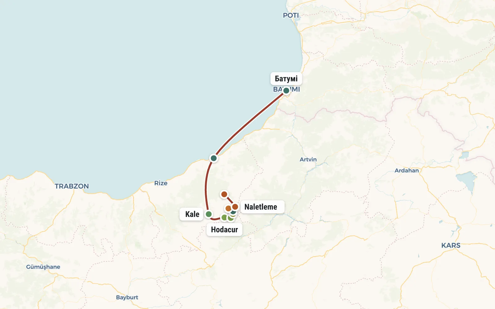 Open the map →
GPS-трек для маршруту ще не оцифровано — лінія орієнтовна (по ключових точках).
Day by dayItinerary
1 Day 1. Батуми, Ардешен, Чат
Поблизости с Качкаром есть два крупных аэропорта - Трабзон (в Турции) и Батуми (в Грузии). Сбор группы либо в аэропорту, либо в поселке Ардешен (2,5 часа от Трабзона)
У Ардешена покидаем прибрежную полосу и едем вглубь континета. По дороге смотрим чайные плантации и делаем остановку для беглого осмотра крепости Zilkale. В деревушке Чат (1200 м) начинается пешая часть маршрута.
Идём по грунтовке вверх по течению реки Heinşin. Река течёт по живописному каньону с водопадиками и старинными арочными мостами. Проходим крошечную деревушку Kaleköy (высота 1800м). В принципе, можно остаться на ночлег и тут. Но чтобы облегчить завтрашнюю акклиматизацию имеет смысл сегодня пройти еще пару часов и стать на ночлег у деревни Başyayla (Баш Яйла, 2200м).
2 Day 2. Pass Kale (2900m) - Hacivanak (2500m)
We finally leave the forest zone. Most of the route passes through alpine meadows. It's easy to navigate, but there's no firewood at all. Therefore, we will cook on burners throughout the trip.
We pass the settlement of Başyayla and leave the bottom of the valley - the ascent to the Kale pass (2900m) begins. The not too well-trodden path goes along an old kurumnik overgrown with grass, in some places it becomes completely lost. You have to step from stone to stone, trying not to fall into the cracks. At the pass we have lunch overlooking the new valley.
Along an equally terrible path with boulders we descend to the abandoned village of Hacivanak (2500m) and set up tents.
3 Day 3. Hodacur pass (3165m) - Davali Yayla.
Today our plan is extremely similar to yesterday. We go upstream of the Külük river and climb along the grass with stones to the Hodacur Geçiti pass (3160m). At the pass we have lunch with a view of Kachkar - the highest peak of these mountains, our goal. Then, if desired, you can make a radial route to the large mountain lake Döner Gölü. We continue our journey along the valley of the Davali river (2500m). Idyllic green meadows and cows. We cross streams several times (over rocks) and the main riverbed (arched bridges). We spend the night near a shepherd's camp at an altitude of 2550 m.
4 Day 4. Mount Soğanli Dag, Lake Deniz Gölü (3370 m).
A long climb (900 meters of climb) will lead to an unnamed pass (about 3400m) separating the Soğanli Dag mountain from the Kachkar ridge. Behind it, first the small lake Atsiz Gölü, and then another transshipment river, awaits us. Immediately after the second pass there will be a large lake Deniz Gölü near which we will put up tents. The altitude here is 3350 meters, which is more than enough for altitude sickness. Therefore, in order to sleep better at night, after lunch we will make an acclimatization hike at least 200 meters up. Early dismissal - tomorrow will be a difficult day.
5 Day 5. Climbing Kachkar (3932m), Shaitan rocks, Dilberdüzu parking lot
Today is the most difficult day of the hike. In order to reach the summit before it gets covered with clouds, we will get up before dawn, have a light snack and, without folding the tent, set off for the ascent.
We take raincoats, water and courage with us. The path to the top is not easy - again there is a lot of powder, there are steep sections where you will have to hold on with your hands, and there may be patches of snow. The ascent will take 3-4 hours. If you're lucky, you can see Ararat and even Elbrus from the top of Kachkar. We have lunch and begin our descent around noon.
The return to camp will also take about 3 hours. We make tea, rest slightly (swim in the icy lake) and fold up the tents. The body needs rest (read oxygen), and for this we must drop 500 meters until the evening and spend the night in the Dilberdüzu clearing (2900m)
Dilberduzu is a very popular stop. Most likely we will meet here international groups of climbers and tourists from all over Europe. And right above this clearing rise the very photogenic Shaitan Rocks (Şeytan Kaylari).
6 Day 6. Olgunlar (2100 m), Düpedüzü (2720 m)
Relatively short day. Actually, it’s very close from Dilberduzu to our next stop. But we are separated from it by the Kachkar spur, and in order to go around it we will first have to go down the Büyük river to the village of Olgunlar (2100 m). There is a store there and you might be able to buy something tasty (fresh bread, ayran). After an early lunch, we begin our ascent through the neighboring Düpedüzü valley. We set up camp at the sources of the river of the same name at an altitude of about 2700m.
7 Day 7. Naletleme pass (3220m), Lake Karadeniz, Ayder (1300m)
Again we go up the kurumnik slopes - a whole sea of stones and a sea of clouds above them. We conquer the last Naletleme pass of this hike (3220m) and thus find ourselves on the other side of the Kachkar ridge. Due to the fact that clouds are constantly creeping in from the north, from the Black Sea, a completely different climate reigns here, and accordingly a different nature. The northern slopes of Kachkar are covered with coniferous forests.
We have lunch at Lake Karadeniz Gölü and descend to the village of Yukari Çaymakçur (1300 m). Another 4 km along the forest road and we find ourselves in the mountain resort of Aider. We put up tents at the campsite (shower, toilet). If you wish, you can go to the thermal baths or a restaurant in the evening.
8 Day 8. Rafting, Trabzon
In fact, the hike along Kachkar is completed, you can fly home. If you wish, you can stay another day in Ayder and go rafting. Or you can go to Trabzon and visit the famous mountain monastery of Panagia Sumela. If you are interested in a seaside holiday, then frankly, it is better to fly from Trabzon to the Mediterranean coast of Turkey - the beaches there are better.
DetailsIncluded
Not included
- ✕Переліт до Туреччини або Грузію (від $ 200)
- ✕Трансфери по маршруту
- ✕Прокат особистого спорядження
- ✕Відвідування платних пам'яток
- ✕Готелі
- ✕Кемпінги і ресторани
- ✕Медичне страхування
Trip conditions
To travel around Turkey you need a passport! But citizens of Ukraine, Russia and Belarus do not need a visa - neither to Turkey nor to Georgia.
All overnight stays are in tents. We will bring most of the products for the trip to Turkey with us; reserve 4-5 kg for them in your luggage. The instructor will purchase some of the products on the spot.
The instructor has the right to make changes to the route depending on weather, group condition and other factors.
Booking
Порядок оплаты: Чтобы забронировать место в группе надо внести предоплату - 50 евро. В случае отказа от участия, предоплата не возвращается, но может быть передана другому участнику или сохранена на будущее (для оплаты других туров). Остаток стоимости тура оплачивается при встрече группы в Турции. В случае преждевременного схода с маршрута, деньги не возвращаются.
ReviewsTraveller reviews
Ми повернулись вже в темряві, орієнтуючись по маячку на наметі... Прийшли по пояс мокрі (форсували кілька річок) але до біса щасливі - що все закінчилось добре, що є ще порох, що гори з нами ))
Майже 4 годин і рівна поверхня стає для нас подарунком. Радість, втома і дивний внутрішній спокій – ми це зробили!
Ще крок, інший…. ЯХУУУУУУУ! Це сталося! Ми на вершині. На десятки кілометрів навколо простягаються космічні пейзажі. Могутність природи і мізерність людини. Дякую, Вам, гори, за дозвіл піднятись. Спокійно, тепло в обіймах всесвіту.