Laugavegur Trek
An ordinary hike in an unusual place - trekking among the unearthly landscapes of Iceland. There will be blue ice, black volcanic valleys, stunning waterfalls, hot geysers and of course hurricane winds and changeable weather (how could we live without it). The mountains themselves are not too difficult, we will mainly struggle with the weather :)
An ordinary hike in an unusual place - trekking among the unearthly landscapes of Iceland. There will be blue ice, black volcanic valleys, stunning waterfalls, hot geysers and of course hurricane winds and changeable weather (how could we live without it). The mountains themselves are not too difficult, we will mainly struggle with the weather :)
Route map
Tour conditions
To participate in a hike in Iceland, you definitely need two things: a Schengen visa and a safety margin. However, for Ukrainian citizens with biometric passports, a visa is no longer required. If you have an old passport, you can obtain a visa through the Norwegian embassy by providing them with a detailed travel plan (we will help you with this) and financial documents. But it would be nice to get a safety margin in advance - to gain experience in other campaigns. Why?
Iceland has very specific weather. In the summer in the mountains the temperature rarely rises above +13, and it usually freezes at night. At the same time, it rains constantly, the sky is overcast. Hurricane winds can easily tear a tent or a fragile raincoat. A hike in such conditions should be approached with as much good equipment as possible. Armor-piercing motivation doesn't hurt either :)
All overnight stays on the Iceland route will be in tents at campsites and special mountain shelters. The campsites have a toilet, hot shower (for an additional fee), and sometimes a kitchen. We cook exclusively on burners (the instructor will have them), you won’t be able to warm up by the fire.
Trek plan:
RouteRoute map
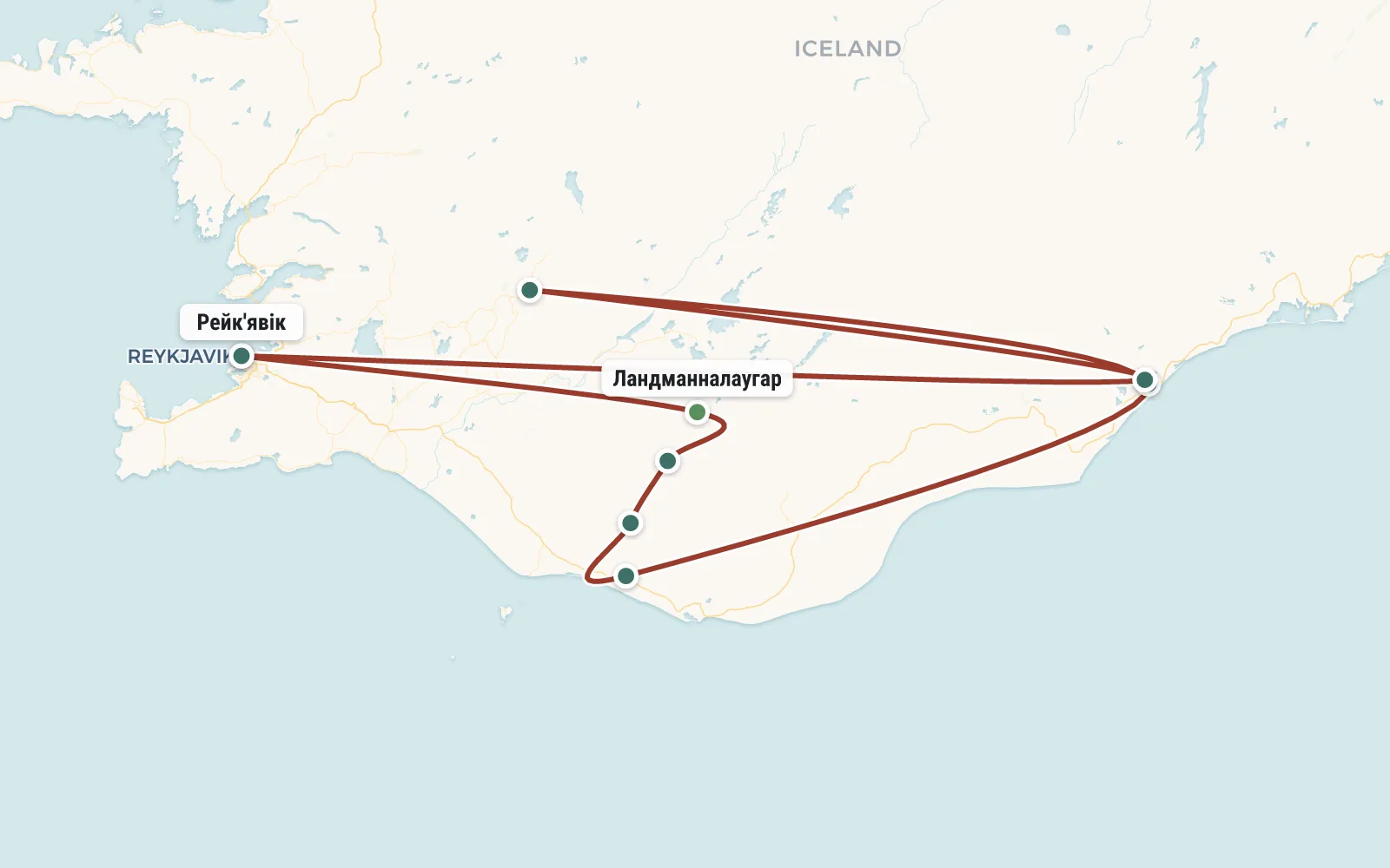 Open the map →
GPS-трек для маршруту ще не оцифровано — лінія орієнтовна (по ключових точках).
Day by dayItinerary
1 Day 1. Flight to Iceland, collection in Reykjavik
The group meets in Reykjavik. Participants travel to Iceland independently (by plane). No one flies directly from the CIS to Iceland; you have to look for options with transfers (most often in Europe). We will try to help you find the most profitable option.
Group gathering at a tent camp in the city center. You can get there from the airport by bus. We will send you detailed travel instructions in advance. The campsite has a shower, a kitchen, and an electrical outlet. There are thermal springs with a bath nearby. After we set up the tents and distribute the food, we can take a walk around the city. It gets dark late here, so there is time.
2 Day 2. Landmannalaugar National Park
Upon arrival (around noon), we set up tents at the campsite and have lunch. Then we go radially to the neighboring volcano Bláhnjúkur (Bláhnjúkur - “blue peak”, height 940m). The base of this small hill is indeed made of greenish-blue rock, and from the top there is an excellent view of the wide valley of the Jökulgilskvisi River. We descend from the Blahnukur volcano along another path that goes through a labyrinth of lava fields. Upon returning to the campsite, we swim in the thermal river flowing nearby (it’s free) and have dinner.
Distance - 3 km, elevation gain - 420 m.
3 Day 3. Brennisteinsalda volcano, Hrafntinnusker shelter
Distance - 12 km, elevation gain - 450 m.
4 Day 4. Lake Álftavatn
Distance - 13 km, elevation gain - 200 m, descent - 700 m.
5 Day 5. Volcanic desert, Emstrur-Botnar shelter, Markarfljótsgljúfur canyon.
We cross the black volcanic desert, against which the green Mount Hattafell (863m) looks like an unreal mirage. The monotonous, dull landscape suddenly gives way to a bewitching panorama: the Mýrdalsjökull glacier advances on the left (Mýrdalsjökull - “mud valley glacier”), and a deep canyon cuts the plain on the right. We spend the night in the Emstrur-Botnar shelter (altitude 520 m), which is hidden in a cozy green ravine - a kind of oasis in the middle of the black desert. In the evening we go on a radial route to that same Markarfljótsgljúfur canyon. The day turns out to be quite long, but the canyon is simply fantastic, and as soon as you see it, your fatigue will disappear :)
Distance - 17 km, elevation gain - 400 m.
6 Day 6. Tórsmork National Park
Distance - 17 km, descent - 300 m.
7 Day 7. Mýrdalsjökull and Eyjafjallajökull glaciers, Fimmvörðuháls volcano
Distance - 18 km, elevation gain - 700 m.
8 Day 8. Skógafoss waterfall, return to Reykjavik
Distance - 8 km, descent - 700 m.
9 Day 9. Start of a road trip around Iceland
DetailsIncluded
Included
- 🧭Супровід російськомовного гіда на всій протяжності програми
- 🍽Триразове похідне харчування на Трекінгові частини маршруту
- 🎒Групове спорядження (пальники, котли, рації, аптечка, тент)
- 🚐Переліт в Ісландію (від $ 300)
- 🎒Прокат спорядження
- 🛡Медична страховка
- 🎫Шенгенська віза
- 🚐Переїзди всередині країни (близько 200 Euro)
- 🏨Платні кемпінги на маршруті і в Рейк'явіку (20 Euro в день)
- •Відвідування платних пам'яток і музеїв
Not included
- ✕Переліт в Ісландію – від €390
- ✕Проживання у платних наметових кемпінгах на треку та в Рейк’явіку – близько €10 з людини за ніч
- ✕Автобус із Рейк’явіка до початку маршруту (Ландманналаугар) – від €70
- ✕Автобус з аеропорту в Рейк’явик і назад – €18 в один бік
- ✕Автобус від кінцевої точки маршруту (Скогар) до Рейк’явіка – від €42
- ✕Оренда спорядження
- ✕Медичне страхування – від €20
- ✕Відвідування платних визначних місць (на маршруті їх немає)
Booking
Порядок оплаты: Чтобы забронировать место в группе надо внести предоплату - 50 евро. В случае отказа от участия, предоплата не возвращается, но может быть передана другому участнику или сохранена на будущее (для оплаты других туров). Остаток стоимости тура оплачивается при встрече группы в Турции. В случае преждевременного схода с маршрута, деньги не возвращаются.
ReviewsTraveller reviews
Тем не менее поход удался. Было очень приятно посмотреть на Карпаты свежим взглядом, было познавательно провести время с детьми в сравнительно экстремальной обстановке, было полезно трезво взглянуть на свои силы и сложность походов в Карпатах.
Исландия это Мордор. Ехать сюда нужно с большим запасом оптимизма и непромокаемой одежды. В нашей группе с этим все в порядке и мы продолжаем улыбаться. Приезжайте ))
Поход по Исландии (тот самый Лейгавегур) скоро закончится и потом мы наверное даже будем скучать по черному песку, свинцовому небу, холодным дождям и ледяным рекам. Со временем.. ))